Estimation of forest parameters using Sentinel 2A data in Pueblo Nuevo, state of Durango
DOI:
https://doi.org/10.29298/rmcf.v12i68.1075Keywords:
English, Basimetric area, aboveground biomass, permanent plots, remote sensing, Sentinel, forest volumeAbstract
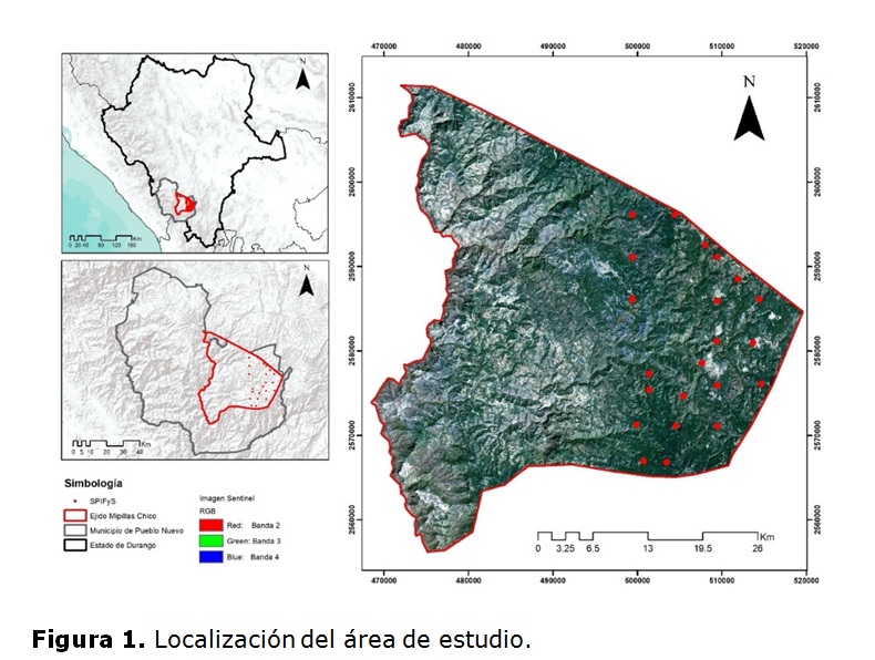
The temperate forests demand periodic monitoring in order to reach a sustainable management. The remote sensing makes it possible to indirectly generate estimates under the assumption of a statistical correlation between satellite data and forest parameters. The aim of this work was to estimate the basimetric area (G), the forest volume (Vta) and the aboveground biomass (W), using spectral data from the Sentinel 2A satellite in the San Bernardino de Milpillas Chico Community, Pueblo Nuevo, state of Durango. A correlation analysis was performed between mensuration information from 22 permanent plots for forest and soil research (SPIFyS) and high-resolution spectral information from the Sentinel 2A sensor. Subsequently, a multiple regression model was developed for each forest stand parameter. The highest correlation coefficient (r) was observed in the NDVI with values of 0.77, 0.68 and 0.76 for the forest parameters of Vta, G and W, respectively. The developed models explained 59 % of the total variance observed for Vta (RCME = m3 ha-1), 58 % for W (RCME = 39.29 Mg ha-1) and 51% for G (RCME = 4.40 m2 ha-1). The NDVI was the main predictive variable in three models. The Sentinel 2A data with a resolution of 10 m in combination with mensuration information from SPIFyS showed a good capacity for mapping forest stand parameters in temperate forests.
Downloads
References
Acosta M., M. R., S. M. E. Pérez, Romero, H. A., González, y A. L. Martínez. 2017. Estimación de la densidad forestal mediante imágenes Landsat ETM+ en la región sur del Estado de México. Revista Mexicana de Ciencias Forestales 8(41): 30-55. Doi:10.29298/rmcf.v8i41.25. DOI: https://doi.org/10.29298/rmcf.v8i41.25
Aguirre-Salado, C. A., J. R. Valdez-Lazalde, G. Ángeles-Pérez, H. M. de los Santos-Posadas y A. I. Aguirre-Salado. 2011. Mapeo del índice de área foliar y cobertura arbórea mediante fotografía hemisférica y datos SPOT 5 HRG: regresión y k-nn. Agrociencia 45(1): 105-119. http://www.scielo.org.mx/scielo.php?script=sci_arttext&pid=S1405-31952011000100010 (2 de marzo de 2021).
Asner G. P. and J. Mascaro. 2014. Mapping tropical forest carbon: Calibrating plot estimates to a simple LiDAR metric. Remote Sensing of Environment 140:614-624. Doi: 10.1016/j.rse.2013.09.023. DOI: https://doi.org/10.1016/j.rse.2013.09.023
Assmann, J. J., I. H. Myers-Smith, J. T. Kerby, A. M., Cunliffe and G. Daskalova. 2020. Drone data reveal heterogeneity in tundra greenness and phenology not captured by satellites. Environmental Research Letters 15(12): 125002. Doi: 10.1088/1748-9326/abbf7d.
Barajas F., H. 2007. Comparación entre análisis discriminante no-métrico y regresión logística multinomial. Tesis de Maestría, Facultad de Ciencias, Universidad Nacional de Colombia. Medellín, Colombia. 67 p.
Casella, A., N. Barrionuevo, A. Pezzola y C. Winschel. 2018. Preprocesamiento de imágenes satelitales del sensor Sentinel 2A y 2B con el software SNAP 6. 0. Instituto de Clima y Agua. CIRN INTA Castelar. Buenos Aires, Argentina. pp. 1-31.
Chrysafis, I., G. Mallinis, S. Siachalou and P. Patias. 2017. Assessing the relationships between growing stock volume and Sentinel-2 imagery in a Mediterranean forest ecosystem. Remote Sensing Letters 8: 508-517. Doi: 10.1080/2150704X.2017.1295479. DOI: https://doi.org/10.1080/2150704X.2017.1295479
Chuvieco, E. 2002. Teledetección Ambiental. La observación de la Tierra desde el Espacio. Editorial Ariel. Barcelona, España. 616 p.
Corral-Rivas, J. J., B. Vargas L., C. Wehenkel, O. A. Aguirre C., J. G. Álvarez G. y A. Rojo A. 2009. Guía para el Establecimiento de Sitios de Investigación Forestal y de Suelos en Bosques del Estado de Durango. Editorial UJED. Durango, Dgo., México. 81 p.
Diéguez-Aranda, U., F. Castedo D. y J. Álvarez G. 2005. Funciones de crecimiento en área basimétrica para masas de Pinus sylvestris L. procedentes de repoblación en Galicia. Investigación Agraria. Sistemas y Recursos Forestales 14(2): 253-266. http://www.inia.es/gcontrec/pub/253-266-(143_04)-Funciones_1162281545765.pdf (2 de marzo de 2021). DOI: https://doi.org/10.5424/srf/2005142-00888
Dos R., A. A., M. C. Carvalho, J. M. De Mello, L. R. Gomide, A. C. Ferraz F. and F. W. A. Junior. 2018. Spatial prediction of basal area and volume in Eucalyptus stands using Landsat TM data: an assessment of prediction methods. New Zealand Journal of Forestry Science 48(1): 1-17. Doi: https://doi.org/10.1186/s40490-017-0108-0. DOI: https://doi.org/10.1186/s40490-017-0108-0
Emborg, J. 1998. Understorey light conditions and regeneration with respect to the structural dynamics of a near-natural temperate deciduous forest in Denmark. Forest Ecology and Management 106: 83-95. Doi: 10.1016/S0378-1127(97)00299-5. DOI: https://doi.org/10.1016/S0378-1127(97)00299-5
Foody, G. M., D. S. Boyd and M. E. J. Cutler. 2003. Predictive relations of tropical forest biomass from Landsat TM data and their transferability between regions. Remote Sensing of Environment 85: 463-474. Doi:10.1016/S0034-4257(03)00039-7. DOI: https://doi.org/10.1016/S0034-4257(03)00039-7
Fuchs, H., P. Magdon, K. Kleinn and H. Flessa. 2009. Estimating aboveground carbon in a catchment of the Siberian forest tundra: Combining satellite imagery and field inventory. Remote Sensing of Environment 113(3): 518-531. Doi:10.1016/j.rse.2008.07.017. DOI: https://doi.org/10.1016/j.rse.2008.07.017
Gadow, K. V., A. Rojo, G. Álvarez-González y R. Rodríguez-Soalleiro. 1999. Ensayos de crecimiento. Parcelas permanentes, temporales y de intervalo. Investigación Agraria. Sistemas y Recursos Forestales 1:299-310. https://recyt.fecyt.es/index.php/IA/article/view/2776 (2 de marzo de 2021).
Gadow, K. V., C. Y. Zhang, C. Wehenkel, A. Pommerening, J. Corral R., M. Korol and X. H. Zhao. 2012. Forest structure and diversity. In: Pukkala, T. and K. von Gadow (eds.). Continuous cover forestry. Springer. Dordrecht, Netherlands. pp. 29-83. Doi: 10.1007/978-94-007-2202-6_2. DOI: https://doi.org/10.1007/978-94-007-2202-6_2
Gibbons, J. D. and S. Chakraborti. 2003. Nonparametric Statistical Interference; Marcel Denker, Inc. New York, NY, USA. 645 p.
Graciano-Ávila, G., E. Alanís-Rodríguez, O. A. Aguirre-Calderón, M. González-Tagle, E. J. Treviño-Garza, A. Mora-Olivo y E. Buendía-Rodríguez. 2019. Estimación de volumen, biomasa y contenido de carbono en un bosque de clima templado-frío de Durango, México. Revista Fitotecnia Mexicana 42(2): 119-127. http://www.scielo.org.mx/pdf/rfm/v42n2/0187-7380-rfm-42-02-119.pdf (2 de marzo de 2021).
Hall, R. J., R. S. Skakun, E. J. Arsenault and B. S. Case. 2006. Modeling forest stand structure attributes using Landsat ETM+ data: Application to mapping of aboveground biomass and stand volume. Forest Ecology and Management 225: 378-390. Doi: 10.1016/j.foreco.2006.01.014. DOI: https://doi.org/10.1016/j.foreco.2006.01.014
Hawryło, P., B. Bednarz, P. Wężyk and M. Szostak. 2018. Estimating defoliation of Scots pine stands using machine learning methods and vegetation indices of Sentinel-2. European Journal of Remote Sensing 51(1): 194-204. Doi:https://doi.org/10.1080/22797254.2017.1417745. DOI: https://doi.org/10.1080/22797254.2017.1417745
Hernández-Ramos, J., X. García-Cuevas, R. Peréz-Miranda, A. González-Hernández y L. Martínez-Ángel. 2020. Inventario y mapeo de variables forestales mediante sensores remotos en el estado de Quintana Roo, México. Madera y Bosques 26(1):e2611884. Doi:10.21829/myb.2020.2611884.
Herold, M., R. M. Román-Cuesta, D. Mollicone, Y. Hirata, P. Van Laake, G. P. Asner, C. Souza, M. Skutsch, V. Avitabile and K. Macdicken. 2011. Options for monitoring and estimating historical carbon emissions from forest degradation in the context of REDD+. Carbon Balance and Management 6: 1-13. Doi:10.1016/j.rse.2009.08.014. DOI: https://doi.org/10.1186/1750-0680-6-13
Hijmans, R. J. 2020. Raster: Geographic Data Analysis and Modeling. R package version 3.4-5. https://CRAN.R-project.org/package=raster (9 de abril de 2021).
Hu, Y., X. Xu, F. Wu, Z. Sun, H. Xia, Q. Meng and X. Xiao. 2020. Estimating forest stock volume in Hunan Province, China, by integrating in situ plot data, Sentinel-2 images, and linear and machine learning regression models. Remote Sensing 12(1): 186. Doi:10.3390/rs12010186.
Instituto Nacional de Estadística y Geografía (Inegi). 2017a. Anuario estadístico y geográfico de Durango. https://www.datatur.sectur.gob.mx/ITxEF_Docs/DGO_ANUARIO_PDF.pdf (15 de julio de 2020).
Instituto Nacional de Estadística y Geografía (Inegi). 2017b. Conjunto de datos vectoriales de uso del suelo y vegetación Escala 1: 250 000. Serie VI (Conjunto nacional). URL: http://www.conabio.gob.mx/informacion/metadata/gis/usv250s6gw.xml?_httpcache=yes&_xsl=/db/metadata/xsl/fgdc_html.xsl&_indent=no (2 de marzo de 2021).
Karjalainen, M., V. Kankare, M. Vastaranta, M. Holopainen and J. Hyyppa. 2012. Prediction of plot-level forest variables using TerraSAR-X stereo SAR data. Remote Sensing of Environment 117: 338–347. Doi:10.1016/j.rse.2011.10.008. DOI: https://doi.org/10.1016/j.rse.2011.10.008
López-Serrano, P. M., C. A. López S., R. Solís-Moreno and J. J. Corral-Rivas. 2016. Geospatial estimation of above ground forest biomass in the Sierra Madre Occidental in the state of Durango, Mexico. Forests 7(3): 70. Doi:10.3390/f7030070. DOI: https://doi.org/10.3390/f7030070
López-Serrano, P. M., C. A. López-Sánchez, J. G. Álvarez-González and J. Garcíaa-Gutiérrez. 2016. A comparison of machine learning techniques applied to landsat-5 TM spectral data for biomass estimation. Canadian Journal of Remote Sensing 42(6): 690-705. Doi: 10.1080/07038992.2016.1217485. DOI: https://doi.org/10.1080/07038992.2016.1217485
López-Serrano, P. M., J. L. Cárdenas D., J. J. Corral-Rivas, E. Jiménez, C. A. López-Sánchez and D. J. Vega-Nieva. 2020. Modeling of aboveground biomass with Landsat 8 OLI and machine learning in temperate forests. Forests 11(1): 11. Doi:10.3390/f11010011.
Louis, J., V. Debaecker, B. Pflug, M. Main-Knorn, J. Bieniarz, J., U. Mueller-Wilm and F. Gascon. 2016. Sentinel-2 Sen2Cor: L2A processor for users. In: Proceedings Living Planet Symposium. 9-13 May 2016. Prague, Czech Republic. 8 p.
Lu, D., P. Mausel, E., Brondízio and E. Moran. 2004. Relationships between forest stand parameters and Landsat TM spectral responses in the Brazilian Amazon Basin. Forest Ecology and Management 198: 149-167. Doi: 10.1016/j.foreco.2004.03.048. DOI: https://doi.org/10.1016/j.foreco.2004.03.048
Miranda-Aragón, L., E. J. Treviño-Garza, J. Jiménez-Pérez, O. A. Aguirre-Calderón, M. A. González-Tagle, M. Pompa-García y C. A. Aguirre-Salado. 2013. Tasa de deforestación en San Luis Potosí, México (1993-2007). Revista Chapingo Serie Ciencias Forestales y del Ambiente 19(2): 201-215. Doi:10.5154/r.rchscfa.2011.06.044. DOI: https://doi.org/10.5154/r.rchscfa.2011.06.044
Myers-Smith, I.H., J. T. Kerby, G. K. Phoenix, J. W. Bjerke, H. E. Epstein, J. J. Assmann, C. J., L Andreu-Hayles, S. Angers-Blondin, P. S. A. Beck, L. T. Berner, U. S. Bhatt, A. D. Bjorkman, D. Blok, A. Bryn, C. T. Christiansen, J. H. C. Cornelissen, A. M. Cunliffe, S. C. Elmendorf, B. C. Forbes, S. J. Goetz, R. D. Hollister, R. Jong, M. M. Loranty, M. Macias-Fauria, K. Maseyk, S. Normand, J. Olofsson, T. C. Parker, F. W. Parmentier, E. Post, G. Schaepman-Strub, F. Stordal, P. F. Sullivan, H. J. D. Thomas, H. Tømmervik, R. Treharne, C. E. Tweedie, D. A. Walker, M. Wilmking and S. Wipf. 2020. Complexity revealed in the greening of the Arctic. Nature Climate Change 10(2): 106-117. Doi:10.1038/s41558-019-0688-1.
Pebesma, E. J. 2004. Multivariable geostatistics in S: the gstat package. Computers and Geosciences 30: 683-691. Doi: 10.1016/j.cageo.2004.03.012. DOI: https://doi.org/10.1016/j.cageo.2004.03.012
Pham, T., N. Yokoya, D. Bui, K. Yoshino and D. Friess. 2019. Remote sensing approaches for monitoring mangrove species, structure, and biomass: Opportunities and challenges. Remote Sensing 11:230. Doi: 10.3390/rs11030230.
Ripley, B. 2020. MASS: Support Functions and Datasets for Venables and Ripley’s Mass. https://CRAN.R-project.org/package=MASS (2 de marzo de 2021).
R Core Team. 2020. R: A language and environment for statistical computing. R Foundation for Statistical Computing, Vienna, Austria. https://www.R-project.org/ (9 de abril de 2021).
Secretaría de Recursos Naturales y Medio Ambiente (SRNyMA). 2016. Programa Estratégico Forestal 2030. Gobierno del Estado de Durango. Durango, Dgo., México. 200 p.
Segura, M. R. y G. Trincado. 2003. Cartografía digital de la Reserva Nacional Valdivia a partir de imágenes satelitales Landsat TM. Bosque (Valdivia) 24(2):43-52. Doi: https://dx.doi.org/10.4067/S0717-92002003000200005. DOI: https://doi.org/10.4067/S0717-92002003000200005
Simental-Cano, B., C. A. López-Sánchez, C. Wehenkel, B. Vargas-Larreta, J. G. Álvarez-González and J. J. Corral-Rivas. 2017. Species-specific and regional volume models for 12 forest species in Durango, Mexico. Revista Chapingo Serie Ciencias Forestales y del Ambiente 3(2): 155-171. Doi: 10.5154/r.rchscfa.2016.01.004. DOI: https://doi.org/10.5154/r.rchscfa.2016.01.004
Sobrino J., A., R. Llorens, C. Fernández, J. M. Fernández A. and A. Vega J. 2019. Relationship between soil burn severity in forest fires measured in situ and through spectral indices of remote detection. Forests 10(5): 457. Doi: 10.3390/f10050457.
Song, C. 2013. Optical remote sensing of forest leaf area index and biomass. Progress in Physical Geography 37: 98-113. Doi: 10.1177/0309133312471367. DOI: https://doi.org/10.1177/0309133312471367
Toledo, M., L. Poorter, M. P. Claros, A. Alarcon, J. Balcázar, C. Leaño, J. C. Licona, O. Llanque, V. Vroomans, P. Zuidema and F. Bongers. 2011. Climate is a stronger driver of tree and forest growth rates than soil and disturbance. Journal of Ecology 99(1): 254-264. Doi: 10.1111/j.1365-2745.2010.01741.x. DOI: https://doi.org/10.1111/j.1365-2745.2010.01741.x
Tomppo, E., Th. Gschwantner, M. Lawrence and E. McRoberts. 2010. National Forest Inventories – Pathways for Common Reporting. Springer book series Managing Forest Ecosystems. Viena, Austria. 612 p. Doi: 10.1007/978-90-481-3233-1. DOI: https://doi.org/10.1007/978-90-481-3233-1
Torres-Rojas, G., M. E. Romero-Sánchez, E. Velasco-Bautista y A. González-Hernández. 2016. Estimación de parámetros forestales en bosques de coníferas con técnicas de percepción remota. Revista Mexicana de Ciencias Forestales 7(36): 7-24. Doi:10.29298/rmcf.v7i36.56. DOI: https://doi.org/10.29298/rmcf.v7i36.56
Torres-Vivar, J. E., J. J. Valdez-Lazalde, G. Ángeles P., H. M. Santos-Posadas y C. A. Aguirre-Salado. 2017. Inventario y mapeo de un bosque bajo manejo de pino con datos del sensor SPOT 6. Revista Mexicana de Ciencias Forestales 8(39): 25-43. Doi:10.29298/rmcf.v8i39.41. DOI: https://doi.org/10.29298/rmcf.v8i39.41
Vargas-Larreta, B., C. A. López-Sánchez, J. J. Corral-Rivas, J. O. López-Martínez, C. G. Aguirre-Calderón and J. G. Álvarez-González. 2017. Allometric equations for estimating biomass and carbon stocks in the temperate forests of North-Western Mexico. Forests 8(8): 269. Doi: 10.3390/f8080269. DOI: https://doi.org/10.3390/f8080269
Verbesselt, J., R. Hyndman, G. Newnham and D. Culvenor. 2010. Detecting trend and seasonal changes in satellite image time series. Remote Sensing of Environment 114: 106–115. Doi: https:10.1016/j.rse.2009.08.014. DOI: https://doi.org/10.1016/j.rse.2009.08.014
Wulder, M. A., S. M. Ortlepp, J. C. White and S. Maxwell. 2014. Evaluation of Landsat-7 SLC-off image products for forest change detection. Canadian Journal of Remote Sensing 34(2): 93-99. Doi: 10.5589/m08-020. DOI: https://doi.org/10.5589/m08-020
Published
How to Cite
Issue
Section
License
Copyright (c) 2021 Revista Mexicana de Ciencias Forestales

This work is licensed under a Creative Commons Attribution-NonCommercial 4.0 International License.
The authors who publish in Revista Mexicana de Ciencias Forestales accept the following conditions:
In accordance with copyright laws, Revista Mexicana de Ciencias Forestales recognizes and respects the authors’ moral right and ownership of property rights which will be transferred to the journal for dissemination in open access.
All the texts published by Revista Mexicana de Ciencias Forestales –with no exception– are distributed under a Creative Commons License Attribution-NonCommercial 4.0 International (CC BY-NC 4.0), which allows third parties to use the publication as long as the work’s authorship and its first publication in this journal are mentioned
The author(s) can enter into independent and additional contractual agreements for the nonexclusive distribution of the version of the article published in Revista Mexicana de Ciencias Forestales (for example, include it into an institutional repository or publish it in a book) as long as it is clearly and explicitly indicated that the work was published for the first time in Revista Mexicana de Ciencias Forestales.
For all the above, the authors shall send the form of Letter-transfer of Property Rights for the first publication duly filled in and signed by the author(s). This form must be sent as a PDF file to: ciencia.forestal2@inifap.gob.mx
This work is licensed under a Creative Commons Attribution-Noncommercial 4.0 International license.