Analysis of the surface temperature in the green areas of the city of Durango, Durango.
DOI:
https://doi.org/10.29298/rmcf.v15i81.1432Keywords:
Urban green areas, Landsat 8, QGIS, Thermal regulation, Land Surface TemperatureAbstract
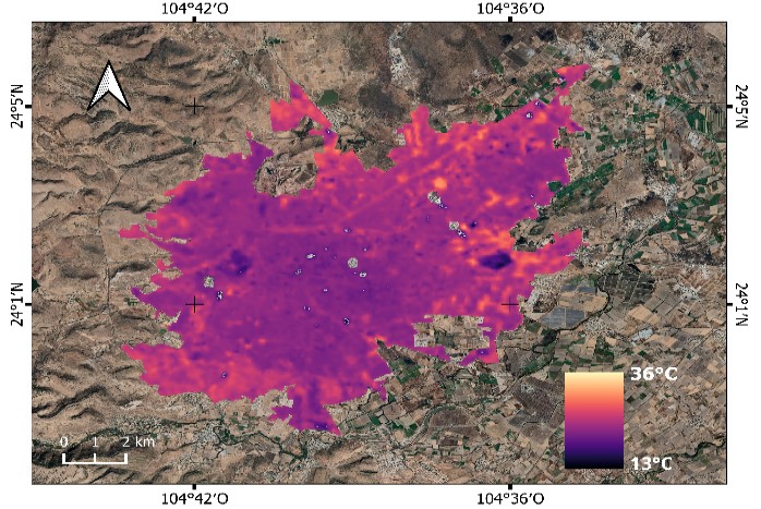
The green areas in urban areas have provided a variety of ecosystem services which influence the quality of life of the inhabitants. The objective of this work was to analyze the effect of green areas on the Land Surface Temperature (LTS) recorded by remote sensors in the city of Durango, Dgo. The existing public and private green areas in the city were differentiated and the area in square meters per inhabitant was calculated. A classification by land use (urban, body of water, bare soil and green area) was carried out in order to analyze the TS derived from Landsat 8 satellite images and geographic information systems (QGIS), in addition a comparison of LTS in three types of green areas (parks, squares and gardens and ridges). The behavior of the LTS was analyzed in two seasons of the year in winter 2021 and spring 2022, identifying the areas with the highest incidence of temperature in two periods. The results indicate a lower LTS in green areas compared to urban areas (concrete, construction and asphalt areas), as well as a regulatory trend in larger green areas (parks). The LTS satellite product allowed to evaluate the temperature in spaces with vegetation within an urban area and it is shown that the larger the green area, the more thermal regulation exists in urban areas.
Downloads
References
Amini, S., M. Saber, H. Rabiei-Dastjerdi and S. Homayouni. 2022. Urban land use and land cover change analysis using Random Forest Classification of Landsat Time Series. Remote Sensing 14(11):2654. Doi: 10.3390/rs14112654. DOI: https://doi.org/10.3390/rs14112654
Aram, F., E. Higueras G., E. Solgi and S. Mansournia. 2019. Urban green space cooling effect in cities. Heliyon 5(4):e01339. Doi: 10.1016/j.heliyon.2019.e01339. DOI: https://doi.org/10.1016/j.heliyon.2019.e01339
Balsa-Barreiro, J., A. J. Morales and R. C. Lois-González. 2021. Mapping population dynamics at local scales using spatial networks. Complexity 2021:1-14. Doi: 10.1155/2021/8632086. DOI: https://doi.org/10.1155/2021/8632086
Becker, F. 1987. The impact of spectral emissivity on the measurement of land surface temperature from a satellite. International Journal of Remote Sensing 8(10):1509-1522. Doi: 10.1080/01431168708954793. DOI: https://doi.org/10.1080/01431168708954793
Blancarte S., R. H. 2016. La relación entre las áreas verdes y la calidad de vida en ambientes urbanos. Tesis de Maestría en Gestión Ambiental. Centro Interdisciplinario de Investigación para el Desarrollo Integral Regional (CIIDIR), Instituto Politécnico Nacional. Durango, Dgo., México. 113 p.
Callejas, I. J. A., A. Santana de O., F. M. de Moura S., L. C. Durante, M. C. de J. Albuquerque N. and P. Zeilhofer. 2011. Relationship between land use/cover and surface temperatures in the urban agglomeration of Cuiabá-Várzea Grande, Central Brazil. Journal of Applied Remote Sensing 5(1):569-573. Doi: 10.1117/1.3666044. DOI: https://doi.org/10.1117/1.3666044
Castro-Mendoza, I., J. R. Valdez-Lazalde, G. Donovan, T. Martínez-Trinidad, F. O. Plascencia-Escalante and W. Vázquez-Morales. 2022. Does land-use affect the temperature distribution across the city of Tuxtla Gutiérrez, Chiapas, México? Investigaciones Geográficas (107):1-19. Doi: 10.14350/rig.60394. DOI: https://doi.org/10.14350/rig.60394
Chávez, P. S. 1988. An improved dark-object subtraction technique for atmospheric scattering correction of multispectral data. Remote Sensing of Environment 24(3):459-479. Doi: 10.1016/0034-4257(88)90019-3. DOI: https://doi.org/10.1016/0034-4257(88)90019-3
Cilliers, S., J. Cilliers, R. Lubbe and S. Siebert. 2013. Ecosystem services of urban green spaces in African countries—perspectives and challenges. Urban Ecosystems 16:681-702. Doi: 10.1007/s11252-012-0254-3. DOI: https://doi.org/10.1007/s11252-012-0254-3
Congalton, R. G. and K. Green. 2008. Assessing the accuracy of remotely sensed data. Principles and practices. CRC Press. Boca Raton, FL, United States of America. 183 p. DOI: https://doi.org/10.1201/9781420055139
Doraiswamy, P. C. and D. R. Thompson. 1982. A crop moisture stress index for large areas and its application in the prediction of spring wheat phenology. Agricultural Meteorology 27(1-2):1-15. Doi: 10.1016/0002-1571(82)90014-0. DOI: https://doi.org/10.1016/0002-1571(82)90014-0
Food and Agriculture Organization of the United Nations (FAO). 2023. Servicios ecosistémicos y biodiversidad. https://www.fao.org/ecosystem-services-biodiversity/background/regulatingservices/es/. (17 de mayo de 2023).
Ghosh, S. and A. Das. 2018. Modelling urban cooling island impact of green space and water bodies on surface urban heat island in a continuously developing urban area. Modeling Earth Systems and Environment 4:501-515. Doi: 10.1007/s40808-018-0456-7. DOI: https://doi.org/10.1007/s40808-018-0456-7
Green Urban Data (GUD). 2019. Temperatura superficial terrestre ¿afecta mi ciudad? https://www.greenurbandata.com/2019/02/20/temperatura-superficial. (14 de marzo de 2023).
Hossain, M. D. and D. Chen. 2019. Segmentation for Object-Based Image Analysis (OBIA): A review of algorithms and challenges from remote sensing perspective. ISPRS Journal of Photogrammetry and Remote Sensing (150):115-134. Doi: 10.1016/j.isprsjprs.2019.02.009. DOI: https://doi.org/10.1016/j.isprsjprs.2019.02.009
Instituto de Evaluación de Políticas Públicas del Estado de Durango (Inevap). 2021. Programa anual de evaluación 2021. Evaluación específica. Programa de crecimiento verde, incluyente, sostenible y sustentable, municipio de Durango. Inevap. Durango, Dgo., México. 116 p. https://implandgo.gob.mx/IMPLAN/Sistema%20de%20Evaluaci%C3%B3n%20del%20Desempe%C3%B1o/Informe%20Final%20Programa%20Crecimiento%20Verde%202021.pdf. (7 de septiembre de 2023).
Instituto Nacional de Estadística y Geografia (Inegi). 2018. Directorio Estadístico Nacional de Unidades Económicas 2018. Información para la actualización e incorporación de unidades económicas al DENUE. Datos a noviembre de 2018 (DENUE-2018). https://www.inegi.org.mx/rnm/index.php/catalog/341/data-dictionary. (15 de marzo de 2023).
Instituto Nacional de Estadística y Geografía (Inegi). 2022. Aspectos geográficos, Durango. Inegi. Aguascalientes, Ags., México. 44 p. https://www.inegi.org.mx/contenidos/app/areasgeograficas/resumen/resumen_10.pdf. (15 de marzo de 2023).
Instituto Nacional de Estadística, Geografía e Informática (INEGI). 2005. Cartografía Geoestadística Urbana 2005. Durango. INEGI. https://www.inegi.org.mx/app/mapas/?t=7100000000000000&tg=3604. (6 de septiembre de 2023).
Jabbar, M., M. M. Yusoff and A. Shafie. 2022. Assessing the role of urban green spaces for human well-being: a systematic review. GeoJournal 87:4405-4423. Doi: 10.1007/s10708-021-10474-7. DOI: https://doi.org/10.1007/s10708-021-10474-7
Javadi, R. and N. Nasrollahi. 2021. Urban green space and health: The role of thermal comfort on the health benefits from the urban green space; a review study. Building and Environment 202:108039. Doi: 10.1016/j.buildenv.2021.108039. DOI: https://doi.org/10.1016/j.buildenv.2021.108039
Konijnendijk, C. 2021. The 3-30-300 rule for urban forestry and greener cities. Biophilic Cities Journal 4(2):1-2. https://static1.squarespace.com/static/5bbd32d6e66669016a6af7e2/t/6101ce2b17dc51553827d644/1627508274716/330300+Rule+Preprint_7-29-21.pdf. (5 de septiembre de 2023).
Kurbán, A., A. Papparelli, M. Cúnsulo, E. Montilla y E. Ríos. 2007. Espacios verdes y variación de la humedad relativa en entornos urbanos áridos. In: Saravia, L., R. Echazú, R. Abalone, R. Caso, … y M. Tamasi (Comps.). XXX Congreso de la Asociación Argentina de Energías Renovables y Medio Ambiente (Asades). Asades. San Luis, D, Argentina. pp. 1-6. http://sedici.unlp.edu.ar/bitstream/handle/10915/94022/Documento_completo.pdf?sequence=1. (6 de mayo de 2023).
Kwok, R. 2018. Ecology’s remote-sensing revolution. Nature 556:137-138. https://www.nature.com/articles/d41586-018-03924-9. (5 de septiembre de 2023). DOI: https://doi.org/10.1038/d41586-018-03924-9
Liaw, A. and M. Wiener. 2002. Classification and Regression by randomForest. R News 2-3:18-22. https://cogns.northwestern.edu/cbmg/LiawAndWiener2002.pdf. (5 de septiembre de 2023).
Liu, C., P. Frazier and L. Kumar. 2007. Comparative assessment of the measures of thematic classification accuracy. Remote Sensing of Environment 107(4):606-616. Doi: 10.1016/j.rse.2006.10.010. DOI: https://doi.org/10.1016/j.rse.2006.10.010
López G., F. M, L. A. Navarro N., R. E. Díaz C. y J. Navarro-Estupiñán. 2021. Cobertura vegetal y la distribución de islas de calor/oasis urbanos en Hermosillo, Sonora. Frontera Norte 33:1-32. Doi: 10.33679/rfn.v1i1.2088. DOI: https://doi.org/10.33679/rfn.v1i1.2088
López-Serrano, P. M., J. J. Corral-Rivas, R. A. Díaz-Varela, J. G. Álvarez-González and C. A. López-Sánchez. 2016. Evaluation of radiometric and atmospheric correction algorithms for aboveground forest biomass estimation using Landsat 5 TM data. Remote Sensing 8(5):369. Doi: 10.3390/rs8050369. DOI: https://doi.org/10.3390/rs8050369
McFeeters, S. K. 1996. The use of the Normalized Difference Water Index (NDWI) in the delineation of open water features. International Journal of Remote Sensing 17(7):1425-1432. Doi: 10.1080/01431169608948714. DOI: https://doi.org/10.1080/01431169608948714
Meyers, J., A. Langston, D. Devereux and B. Lin. 2020. Mapping land surface temperatures and heat-health vulnerability in Darwin. Commonwealth Scientific and Industrial Research Organisation (CSIRO). Canberra, ACT, Commonwealth of Australia. https://research.csiro.au/darwinlivinglab/wp-content/uploads/sites/278/2020/12/CSIRO_Mapping_LST__Heat_Health_Vulnerability_In_Darwin_Final.pdf. (28 de septiembre de 2023).
Organización de las Naciones Unidas (ONU). 2020. Día Mundial de las Ciudades: Las comunidades son la raíz de las urbes sostenibles. https://news.un.org/es/story/2020/10/1483282. (3 de marzo de 2023).
Programa de las Naciones Unidas para el Medio Ambiente (PNUMA). 2011. Informe Anual 2010. Síntesis del año. PNUMA. Nairobi, KE, Kenia. 124 p. https://www.iri.edu.ar/publicaciones_iri/anuario/cd_anuario_2011/Mayd/Programa%20de%20las%20Naciones%20Unidas%20para%20el%20Medio%20Ambiente%20-%20Informe%202010.pdf. (28 de septiembre de 2023).
QGIS Development Team. 2020. Geographic Information System version 3.14. Open Source Geospatial Foundation Project. http://qgis.osgeo.org. (26 de enero de 2020).
Qiu, G. Y., H. Y. Li, Q. T. Zhang, W. Chen, X. J. Liang and X. Z. Li. 2013. Effects of evapotranspiration on mitigation of urban temperature by vegetation and urban agriculture. Journal of Integrative Agriculture 12(8):1307-1315. Doi: 10.1016/S2095-3119(13)60543-2. DOI: https://doi.org/10.1016/S2095-3119(13)60543-2
Rendón G., R. E. 2010. Espacios verdes públicos y calidad de vida. In: Centre de Política de Sòl i Valoracions y Universidad Autónoma de Baja California (Edits.). Memorias del 6o Congreso Internacional Ciudad y Territorio Virtual. Centre de Política de Sòl i Valoracions y Universidad Autónoma de Baja California. Mexicali, BC, México. pp. 1-14. https://upcommons.upc.edu/handle/2099/12860. (14 de marzo de 2023).
Romero B., R. 2017. Lima tiene un déficit de 56 millones de metros cuadrados de áreas verdes. https://rpp.pe/politica/actualidad/lima-tiene-un-deficit-de-61-millones-de-metros-cuadrados-en-areas-verdes-noticia-1021931. (6 de septiembre de 2023).
Rouse, J. W., R. H. Haas, J. A. Schell and D. W. Deering. 1974. Monitoring vegetation systems in the Great Plains with ERTS. In: Freden, C. S. and E. P. Mercanti (Edits.). Proceedings of the Third ERTS-1 Symposium. National Aeronautics and Space Administration. Washington, DC, United States of America. pp. 309-317.
Sarricolea E., P. y H. Romero A. 2010. Análisis de los factores condicionantes sobre las temperaturas de emisión superficial en el área metropolitana de Valparaíso, Chile. ACE: Architecture, City and Environment 5(14):79-96. Doi: 10.5821/ace.v5i14.2507. DOI: https://doi.org/10.5821/ace.v5i14.2507
Soto-Soto, J. E., J. Garzón-Barrero y G. Jiménez-Cleves. 2020. Análisis de islas de calor urbano usando imágenes Landsat: caso de estudio Armenia-Colombia 1996-2018. Revista Espacios 41(8):9. https://www.revistaespacios.com/a20v41n08/a20v41n08p09.pdf. (5 de septiembre de 2023).
Ullah, S., K. Ahmad, R. U. Sajjad, A. M. Abbasi, A. Nazeer and A. A. Tahir. 2019. Analysis and simulation of land cover changes and their impacts on land surface temperature in a lower Himalayan region. Journal of Environmental Management 245:348-357. Doi: 10.1016/j.jenvman.2019.05.063. DOI: https://doi.org/10.1016/j.jenvman.2019.05.063
United States Geological Survey (USGS). 2017. Landsat 8. Discover the science that our satellites bring to you. https://geonarrative.usgs.gov/landsat-8/. (14 de marzo de 2023).
Villalba M., J. C. 2017. Las áreas verdes urbanas y su relación con la infiltración de agua al subsuelo como servicio ambiental en Xalapa, Veracruz. Tesis de Maestría en Desarrollo Regional Sustentable. El Colegio de Veracruz. Xalapa de Enríquez, Ver., México. 111 p.
World Health Organization (WHO). 2012. Health indicators of sustainable cities in the context of the Rio+20. UN Conference on Sustainable Development. https://www.who.int/docs/default-source/environment-climate-change-and-health/sustainable-development-indicator-cities.pdf?sfvrsn=c005156b_2. (6 de septiembre de 2023).
Downloads
Published
How to Cite
Issue
Section
License
Copyright (c) 2024 Revista Mexicana de Ciencias Forestales

This work is licensed under a Creative Commons Attribution-NonCommercial 4.0 International License.
The authors who publish in Revista Mexicana de Ciencias Forestales accept the following conditions:
In accordance with copyright laws, Revista Mexicana de Ciencias Forestales recognizes and respects the authors’ moral right and ownership of property rights which will be transferred to the journal for dissemination in open access.
All the texts published by Revista Mexicana de Ciencias Forestales –with no exception– are distributed under a Creative Commons License Attribution-NonCommercial 4.0 International (CC BY-NC 4.0), which allows third parties to use the publication as long as the work’s authorship and its first publication in this journal are mentioned
The author(s) can enter into independent and additional contractual agreements for the nonexclusive distribution of the version of the article published in Revista Mexicana de Ciencias Forestales (for example, include it into an institutional repository or publish it in a book) as long as it is clearly and explicitly indicated that the work was published for the first time in Revista Mexicana de Ciencias Forestales.
For all the above, the authors shall send the form of Letter-transfer of Property Rights for the first publication duly filled in and signed by the author(s). This form must be sent as a PDF file to: ciencia.forestal2@inifap.gob.mx
This work is licensed under a Creative Commons Attribution-Noncommercial 4.0 International license.