Measuring forest inventory parameters in planted forests using LiDAR technology: Comparison of methods
DOI:
https://doi.org/10.29298/rmcf.v16i87.1488Keywords:
parámetros forestales, software de uso libre, escaneo láser terrestre, Sensor LIDAR móvil, iPad Pro, realidad aumentadaAbstract
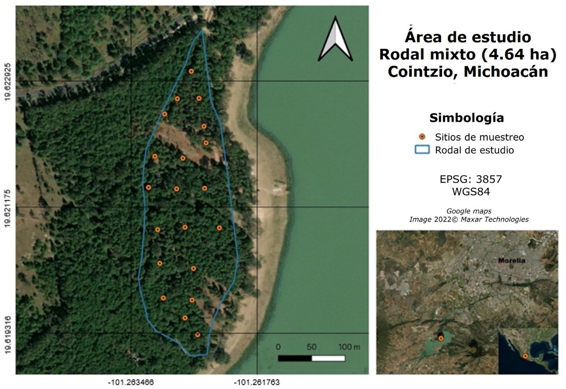
Forest inventory describes the quantity, size, and quality of the trees in a forest and the characteristics of the space where they grow. Traditionally, a forest inventory is carried out manually, with calipers to measure the diameter at breast height (DBH), and devices that use geometric principles, such as the clinometer for the estimation of total height (TH). This paper documents the applicability of a tablet with integrated LiDAR technology for the measurement of forest inventory parameters, by comparing dendrometric data obtained with LiDAR and traditional methods: geographic position, DBH, TH, crown diameter (CD) and clear stem height (CS) of individual trees in a planted coniferous forest. A simple linear regression analysis was performed with each variable, and a t-student test was applied to determine differences between means, as well as to calculate the Root Mean Square Error (RMSE) to measure the error between predicted and observed values. The results show a R2=0.99 and RMSE=0.657 cm for DBH; a R2=0.98 and a RMSE=0.369 m for TH; a R2=0.95 and RMSE=0.341 cm for CD, and a R2=0.97 and RMSE=0.208 cm for CS. The total scanning time for LiDAR data acquisition was 3.4 times less than traditional forest inventory time. The proposed method for forest inventory in planted forests using the mobile device is reliable, accurate, and less time-consuming than the traditional approach.
Downloads
References
Ahamed, A., Foye, J., Poudel, S., Trieschman, E. & Fike, J. (2023). Measuring tree diameter with photogrammetry using mobile phone cameras. Forests, 14(10), 2027. https://doi.org/10.3390/f14102027 DOI: https://doi.org/10.3390/f14102027
Apple Inc. (2022, April 11). Store. Gift magic this holiday. Apple store. https://www.apple.com/store
Arboreal AB. (2022, March 22). Arboreal-Tree (3.5) [Aplicación móvil]. Apple Store. https://apps.apple.com/us/app/arboreal-tree/id1444138299
Ayrey, E. & Hayes, D. J. (2018). The use of three-dimensional convolutional neural networks to interpret LiDAR for forest inventory. Remote Sensing, 10(4), 649. https://doi.org/10.3390/rs10040649 DOI: https://doi.org/10.3390/rs10040649
Bauwens, S., Bartholomeus, H., Calders, K. & Lejeune, P. (2016). Forest inventory with terrestrial LiDAR: A comparison of static and hand-held mobile laser scanning. Forests, 7(6), 127. https://doi.org/10.3390/f7060127 DOI: https://doi.org/10.3390/f7060127
Bobrowski, R., Winczek, M., Silva, L. P., Cuchi, T., Szostak, M. & Wezyk, P. (2022). Promising uses of the iPad Pro point clouds: The case of the trunk flare diameter estimation in the urban forest. Remote Sensing, 14(18), 4661. https://doi.org/10.3390/rs14184661 DOI: https://doi.org/10.3390/rs14184661
Brach, M., Tracz, W., Krok, G. & Gasior, J. (2023). Feasibility of low-cost lidar scanner implementation in forest sampling techniques. Forests, 14(4), 706. https://doi.org/10.3390/f14040706 DOI: https://doi.org/10.3390/f14040706
Brouwer, T. 2013. Low budget ranging for forest management. A microsoft kinect study [Master’s Thesis, Wageningen University]. https://edepot.wur.nl/309838
Çakir, G. Y., Post, C. J., Mikhailova, E. A. & Schlautman, M. A. (2021). 3D LiDAR Scanning of urban forest structure using a consumer tablet. Urban Science, 5(4), 88. https://doi.org/10.3390/urbansci5040088 DOI: https://doi.org/10.3390/urbansci5040088
Calders, K. (2015). Terrestrial laser scanning for forest monitoring [Doctoral’s Thesis, Wageningen University]. Researchgate. https://www.researchgate.net/publication/271212221_Terrestrial_laser_scanning_for_forest_monitoring
Ciesielski, M. & Sterenczak, K. (2019). Accuracy of determining specific parameters of the urban forest using remote sensing. iForest-Biogeosciences and Forestry, 12(6), 498-510. https://doi.org/10.3832/ifor3024-012 DOI: https://doi.org/10.3832/ifor3024-012
Cochran, W. G. (1977). Sampling techniques. John Wiley & Sons. https://fsapps.nwcg.gov/gtac/CourseDownloads/IP/Cambodia/FlashDrive/Supporting_Documentation/Cochran_1977_Sampling%20Techniques.pdf
Comisión Nacional Forestal. (2014). Inventario Nacional Forestal y de Suelos. Procedimientos de muestreo. Versión 1.2. Muestreo 2014. Comisión Nacional Forestal. www.conafor.gob.mx/apoyos/docs/externos/2022/DocumentosMetodologicos/2014/Anexo_procedimientos_muestreo_2014.pdf
Dai, W., Yang, B., Liang, X., Dong, Z., Huang, R., Wang, Y. & Li, W. (2019). Automated fusion of forest airborne and terrestrial point clouds through canopy density analysis. ISPRS Journal of Photogrammetry and Remote Sensing, 156, 94-107. https://doi.org/10.1016/j.isprsjprs.2019.08.008 DOI: https://doi.org/10.1016/j.isprsjprs.2019.08.008
Elsherif, A., Gaulton, R. & Mills, J. (2018). Estimation of vegetation water content at leaf and canopy level using dual-wavelength commercial terrestrial laser scanners. Interface Focus, 8(2), Article 29503721. https://doi.org/10.1098/rsfs.2017.0041 DOI: https://doi.org/10.1098/rsfs.2017.0041
Estornell, J., Velázquez-Martí, A., Fernández-Sarría, A., López-Cortés, I., Martí-Gavilá J. & Salazar, D. (2017). Estimation of structural attributes of walnut trees based on terrestrial laser scanning. Revista de Teledetección, (48), 67-76. https://doi.org/10.4995/raet.2017.7429 DOI: https://doi.org/10.4995/raet.2017.7429
Fan, Y., Feng, Z., Mannan, A., Khan, T. U., Shen, C. & Saeed, S. (2018). Estimating tree position, diameter at breast height, and tree height in real-time using a mobile Phone with RGB-D SLAM. Remote Sensing, 10(11), 1845. https://doi.org/10.3390/rs10111845 DOI: https://doi.org/10.3390/rs10111845
Gollob, C., Ritter, T., Kraßnitzer, R., Tockner, A. & Nothdurft, A. (2021). Measurement of forest inventory parameters with Apple iPad Pro and integrated LiDAR technology. Remote Sensing, 13(16), 3129. https://doi.org/10.3390/rs13163129 DOI: https://doi.org/10.3390/rs13163129
Guenther, M., Heenkenda, M. K., Morris, D. & Leblon, B. (2024). Tree diameter at breast height (DBH) estimation using an iPad Pro LiDAR scanner: A case study in boreal forests, Ontario, Canada. Forests, 15(1), 214. https://doi.org/10.3390/f15010214 DOI: https://doi.org/10.3390/f15010214
Gülci, S., Yurtseven, H., Akay, A. O. & Akgul, M. (2023). Measuring tree diameter using a LiDAR-equipped smartphone: a comparison of smartphone-and caliper-based DBH. Environmental Monitoring and Assessment, 195, Article 678. https://doi.org/10.1007/s10661-023-11366-8 DOI: https://doi.org/10.1007/s10661-023-11366-8
Heo, H. K., Lee, D. K., Park, J. H. & Thorne, J. H. (2019). Estimating the heights and diameters at breast height of trees in an urban park and along a street using mobile LiDAR. Landscape and Ecological Engineering, 15, 253-263. https://doi.org/10.1007/s11355-019-00379-6 DOI: https://doi.org/10.1007/s11355-019-00379-6
Hernández M., J. A. (2020). Desarrollo de un método biométrico, mediante escáner láser terrestre, aplicado a bosques mixtos, en la Reserva de la Biosfera Mariposa Monarca [Tesis de doctorado, Colegio de Postgraduados, Campus Montecillo]. Researchgate. https://www.researchgate.net/publication/357229317_Desarrollo_de_un_metodo_biometrico_mediante_escaner_laser_terrestre_aplicado_a_bosques_mixtos_en_la_RBMM?_tp=eyJjb250ZXh0Ijp7ImZpcnN0UGFnZSI6InByb2ZpbGUiLCJwYWdlIjoicHJvZmlsZSIsInBvc2l0aW9uIjoicGFnZUNvbnRlbnQifX0
Hyyppä, J., Virtanen, J. P., Jaakkola, A., Yu, X., Hyyppä, H. & Liang, X. (2018). Feasibility of Google Tango and kinect for crowdsourcing forestry information. Forests, 9(1), 6. https://doi.org/10.3390/f9010006 DOI: https://doi.org/10.3390/f9010006
Infante G., S. y Zárate de L., G. P. (2012). Métodos estadísticos: un enfoque interdisciplinario. Editorial del Colegio de Postgraduados.
Ko, C., Lee, S., Yim, J., Kim, D. & Kang, J. (2021). Comparison of forest inventory methods at plot-level between a backpack personal laser scanning (BPLS) and conventional equipment in Jeju Island, South Korea. Forests, 12(3), 308. https://doi.org/10.3390/f12030308 DOI: https://doi.org/10.3390/f12030308
Kuželka, K., Slavík, M. & Surový, P. (2020). Very high-density point clouds from UAV laser scanning for automatic tree stem detection and direct diameter measurement. Remote Sensing, 12(8):1236. https://doi.org/10.3390/rs12081236 DOI: https://doi.org/10.3390/rs12081236
Liang, X., Kukko, A., Kaartinen, H., Hyyppä, J., Yu, X., Jaakkola, A. & Wang, Y. (2014). Possibilities of a personal laser scanning system for forest mapping and ecosystem services. Sensors, 14(1), 1228-1248. https://doi.org/10.3390/s140101228 DOI: https://doi.org/10.3390/s140101228
Liang, X., Kankare, V., Hyyppä, J., Wang, Y., Kukko, A., Haggrén, H., Yu, X., Kaartinen, H., Jaakkola, A., Guan, F., Holopainen, M. & Vastaranta, M. (2016). Terrestrial laser scanning in forest inventories. ISPRS Journal of Photogrammetry and Remote Sensing, 115, 63-77. https://doi.org/10.1016/j.isprsjprs.2016.01.006 DOI: https://doi.org/10.1016/j.isprsjprs.2016.01.006
Liang, X., Hyyppä, J., Kaartinen, H., Lehtomäki, M., Pyörälä, J., Pfeifer, N., Holopainen, M., Brolly, G., Francesco, P., Hackenberg, J., Huang, H., Jo, H.-W., Katoh, M., Liu, L., Mokroš, M., Morel, J., Olofsson, K., Poveda-Lopez, J., Trochta, J., … & Wang, Y. (2018). International benchmarking of terrestrial laser scanning approaches for forest inventories. ISPRS Journal of Photogrammetry and Remote Sensing, 144, 137-179. https://doi.org/10.1016/j.isprsjprs.2018.06.021 DOI: https://doi.org/10.1016/j.isprsjprs.2018.06.021
Liu, T., Chang, L., Niu, X. & Liu, J. (2020). Pole-like object extraction and pole-aided GNSS/IMU/LiDAR-SLAM system in urban area. Sensors, 20(24), 7145. https://doi.org/10.3390/s20247145 DOI: https://doi.org/10.3390/s20247145
MAPRY Co. Ltd. (2022, April 20). ForestScanner (1.0.2) [Aplicación móvil]. Apple store. https://apps.apple.com/bo/app/forestscanner/id1599055402
McGlade, J., Wallace, L., Reinke, K. & Jones, S. (2022). The potential of low-cost 3D imaging technologies for forestry applications: Setting a research agenda for low-cost remote sensing inventory tasks. Forests, 13(2), 204. https://doi.org/10.3390/f13020204 DOI: https://doi.org/10.3390/f13020204
Mokroš, M., Mikita, T., Singh, A., Tomaštík, J., Chudá, J., Wężyk, P., Kuželka, K., Surový, P., Klimánek, M., Zięba-Kulawik, K., Bobrowski, R. & Liang, X. (2021). Novel low-cost mobile mapping systems for forest inventories as terrestrial laser scanning alternatives. International Journal of Applied Earth Observation and Geoinformation, 104, Article 102512. https://doi.org/10.1016/j.jag.2021.102512 DOI: https://doi.org/10.1016/j.jag.2021.102512
Musálem, M. A. (2006). Silvicultura de plantaciones forestales comerciales. Universidad Autónoma Chapingo, División de Ciencias Forestales. https://dicifo.chapingo.mx/pdf/publicaciones/silvicultura_plantaciones_forestales_comerciales_2006.pdf
Newnham, G. J., Armston, J. D., Calders, K., Disney, M. I., Lovell, J. L., Schaaf, C. B. & Danson, F. M. (2015). Terrestrial laser scanning for plot-scale forest measurement. Current Forestry Reports, 1, 239-251. https://doi.org/10.1007/s40725-015-0025-5 DOI: https://doi.org/10.1007/s40725-015-0025-5
Piermattei, L., Karel, W., Wang, D., Wieser, M., Mokroš, M., Surový, P., Koreň, M., Tomaštík, J., Pfeifer, N. & Hollaus, M. (2019). Terrestrial structure from motion photogrammetry for deriving forest inventory data. Remote Sensing, 11(8), 950. https://doi.org/10.3390/rs11080950 DOI: https://doi.org/10.3390/rs11080950
Ritter, T., Schwarz, M., Tockner, A., Leisch, F. & Nothdurft, A. (2017). Automatic mapping of forest stands based on three-dimensional point clouds derived from terrestrial laser-scanning. Forests, 8(8), 265. https://doi.org/10.3390/f8080265 DOI: https://doi.org/10.3390/f8080265
Tatsumi, S., Yamaguchi, K. & Furuya, N. (2021). ForestScanner: A mobile application for measuring and mapping trees with LiDAR-equipped iPhone and iPad. Methods in Ecology and Evolution, 14(7), 1603-1609. https://doi.org/10.1101/2021.12.11.472207 DOI: https://doi.org/10.1111/2041-210X.13900
Tomaštík, J., Saloň, Š., Tunák, D., Chudý, F. & Kardoš, M. (2017). Tango in forests–An initial experience of the use of the new Google technology in connection with forest inventory tasks. Computers and Electronics in Agriculture, 141, 109-117. https://doi.org/10.1016/j.compag.2017.07.015 DOI: https://doi.org/10.1016/j.compag.2017.07.015
Wang, F., Heenkenda, M. K. & Freeburn, J. T. (2022). Estimating tree diameter at breast height (DBH) using an iPad Pro LiDAR sensor. Remote Sensing Letters, 13(6), 568-578. https://doi.org/10.1080/2150704X.2022.2051635 DOI: https://doi.org/10.1080/2150704X.2022.2051635
West, P. W. (2009). Tree and forest measurement (2nd Edition). Springer Berlin. DOI: https://doi.org/10.1007/978-3-540-95966-3
Zhou, S., Kang, F., Li, W., Kan, J., Zheng, Y. & He, G. (2019). Extracting diameter at breast height with a handheld mobile LiDAR system in an outdoor environment. Sensors, 19(14), 3212. https://doi.org/10.3390/s19143212 DOI: https://doi.org/10.3390/s19143212
Published
How to Cite
Issue
Section
License
Copyright (c) 2024 Revista Mexicana de Ciencias Forestales

This work is licensed under a Creative Commons Attribution-NonCommercial 4.0 International License.
The authors who publish in Revista Mexicana de Ciencias Forestales accept the following conditions:
In accordance with copyright laws, Revista Mexicana de Ciencias Forestales recognizes and respects the authors’ moral right and ownership of property rights which will be transferred to the journal for dissemination in open access.
All the texts published by Revista Mexicana de Ciencias Forestales –with no exception– are distributed under a Creative Commons License Attribution-NonCommercial 4.0 International (CC BY-NC 4.0), which allows third parties to use the publication as long as the work’s authorship and its first publication in this journal are mentioned
The author(s) can enter into independent and additional contractual agreements for the nonexclusive distribution of the version of the article published in Revista Mexicana de Ciencias Forestales (for example, include it into an institutional repository or publish it in a book) as long as it is clearly and explicitly indicated that the work was published for the first time in Revista Mexicana de Ciencias Forestales.
For all the above, the authors shall send the form of Letter-transfer of Property Rights for the first publication duly filled in and signed by the author(s). This form must be sent as a PDF file to: ciencia.forestal2@inifap.gob.mx
This work is licensed under a Creative Commons Attribution-Noncommercial 4.0 International license.